|
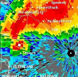 |
| Doppler radar image. Click on the picture to learn more. |
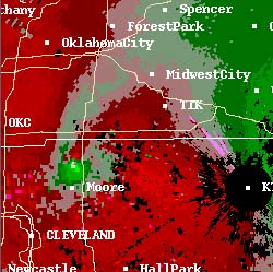 |
| Doppler radar image. Click on the picture to learn more. |
Not all tornadoes are that strong, but some are stronger. The Fujita scale estimates the power of a given tornado by assessing the kind of damage it has done to human-built structures. F-0 is the weakest rating, and F-5 the strongest. Estimated wind speeds within the funnel itself are based upon what would be necessary to cause the amount of damage seen, and also upon measurements taken by scientists doing research such as NSSL's VORTEX. Fortunately, most tornadoes are low-strength. Fewer than 2% of all tornadoes are F-4 or F-5 storms, but they take 80% of lives lost to tornadoes. Seven out of ten tornadoes are F-0 or F-1, and almost all the rest are F-2 and F-3. Most tornadoes can be survived by following National Weather Service guidelines to go into an innermost room on the ground floor of a structure.
What should you do if a tornado is nearby? At that moment, the safety of yourself and others in your household may depend on you making the right decision. What you do can even affect others in your community; motorists who blocked highways may have caused injuries and deaths in the 1998 Oklahoma City tornadoes, that could otherwise have been avoided.
Go to Next Page: EXPERIENTIAL WAYS OF LEARNING AND KNOWING ABOUT TORNADOES

These people provided invaluable advice, explanations, images, and editorial
assistance to the creation of these pages.
Any errors that might still exist on these pages are solely the responsibility of Tapestry.
Copyright © 2007-2008 Tapestry Institute. All rights reserved. Privacy Policy